Far from any coastline, a winter storm whipped the North Pacific into a heaving mass, sending something unusual racing across the ocean.
In the weeks that followed, scientists watched from space as that distant tempest generated waves so tall and so long-lived that they crossed entire oceans, quietly rewriting what we thought we knew about wave power.
When a remote storm sends walls of water around the planet
At the end of 2024, a powerful system nicknamed Storm Eddie formed in the North Pacific. It never became a famous landfalling monster. Instead, it stayed mostly out at sea, churning over deep water.
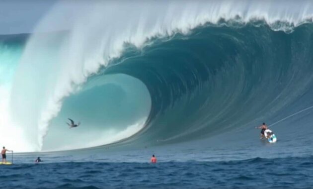
Out there, beyond shipping lanes and weather buoys, Eddie created something astonishing. Average significant wave heights above 19 metres were recorded in the heart of the storm. Individual “rogue-style” crests are estimated to have reached around 35 metres – roughly the height of an 11‑storey building.
These giant waves travelled nearly 24,000 kilometres, looping from the North Pacific through the Drake Passage and into the tropical Atlantic.
Along the way, they brushed past Hawaii and California, lighting up legendary big-wave spots and helping make conditions for events such as the Eddie Aikau Invitational. For surfers, it was a season to remember. For oceanographers, it was a once-in-decades natural experiment.
Unlike hurricanes that slam directly into coasts, Eddie’s main impact was remote. It generated long-period swells that held on to their energy over immense distances. Those swells were the ones satellites started to track with unprecedented precision.
How satellites are now “feeling” the height of the sea
For decades, scientists relied on sparse buoys, ship logs and computer models to estimate wave heights in the open ocean. Direct measurements of the biggest waves were rare and scattered. That changed with the Surface Water and Ocean Topography (SWOT) satellite, a joint mission from NASA and the French space agency CNES.
Launched to map the fine details of sea-surface height, SWOT carries radar instruments capable of detecting subtle bumps and dips in the ocean surface. From those data, researchers can reconstruct the shape and energy of long waves, even when they are hundreds of kilometres wide.
SWOT can identify wave systems with crest-to-crest distances above 500 metres and track them thousands of kilometres from where they were born.
➡️ Express chignon: a party hairstyle in under 1 minute
➡️ Germany pulls off a breakthrough in quantum teleportation, paving the way for tomorrow’s internet
➡️ This toothpaste that protects the microbiome slows harmful bacteria and preserves oral balance
➡️ China Gives Airbus An Early Christmas Gift As Tianjin Factory Crosses Symbolic Milestone
In December 2024, as Eddie’s swell radiated out across the Pacific, SWOT happened to be in exactly the right place. Satellite passes captured swells with periods up to 30 seconds – meaning half a minute between successive crests. That is a signature of extremely long and energetic waves, far beyond what most coastal storms produce.
Old models versus a harsher reality
The detailed SWOT measurements allowed a Franco-European team led by oceanographer Fabrice Ardhuin to confront long-standing theory with hard numbers. Their work, later published in the journal Proceedings of the National Academy of Sciences, revealed that traditional formulas had a serious blind spot.
For years, empirical models had suggested that the longest waves carried vast amounts of energy, spread fairly evenly across the swell. The new data show something different: the energy is far more unevenly distributed.
Instead of a uniform train of powerful waves, most of the energy sits inside a small number of dominant giants, interspersed with much smaller crests.
Old rules of thumb overstated the energy carried by the very longest waves by up to a factor of twenty. That means previous risk assessments may have misjudged how that energy arrives at a coast or an offshore structure.
To understand the change, Ardhuin’s team built a new “spectral” description of extreme seas. In simple terms, they accounted for complex interactions between shorter choppy waves and long rolling swells. Those non-linear interactions were usually simplified away in older models because nobody had the data to test them.
What 35‑metre waves mean for coasts and shipping
These results go far beyond academic curiosity. Long-period swells from distant storms can be deceptively dangerous. Skies may be clear at the beach, but energy released thousands of kilometres away is still on the move.
When those swells arrive in shallower water, they steepen and sometimes stack up, making individual waves much more powerful than local winds would suggest. That affects erosion, coastal flooding and the design limits of infrastructure.
- Beaches: increased erosion and rapid reshaping of sandbars and dunes.
- Ports and harbours: unusual rocking of moored ships and stress on breakwaters.
- Low-lying coasts: “sneaker” flood events, even during calm weather and high-pressure systems.
- Offshore platforms: higher loads on legs and moorings than standard design waves foresee.
In some cases, the arrival of long swells can also amplify existing tides or storm surges. The timing of a remote swell with a local high tide becomes critical. A few extra tens of centimetres of water running on top of unusually energetic waves can push water into streets that would normally stay dry.
Climate change and a more energetic ocean
Researchers are cautious about making bold claims, but they are asking a tough question: are storms like Eddie getting more intense in a warming climate? The answer is not yet clear.
Climate models suggest that in some ocean basins, extreme winds may strengthen, even as overall storm numbers change only slightly. More energy in the atmosphere often means more energy can be transferred into the sea surface. Yet local factors complicate the picture: seafloor shape, island chains and currents all influence how swells grow and spread.
What satellites add is a long-term, global record of how wave energy moves, not just where winds are strongest at any given moment.
That record will feed into updated coastal planning rules. Engineers designing seawalls, piers or wind farms now have evidence that rare, long-period waves can pack more punch than earlier handbooks suggested. Standards may need to shift accordingly.
From rogue waves to “micro-quakes”: hidden effects of giant swells
One less visible consequence of enormous swells is “microseisms”: tiny vibrations they send through Earth’s crust when they pound the seafloor. Seismologists pick up those signals on instruments thousands of kilometres away. They can complicate the detection of small earthquakes, but they also act as another window into how the sea is behaving.
The new wave spectra derived from Eddie’s storm give geophysicists better tools to interpret those background rumbles. When satellites and seismometers tell a consistent story about wave energy, confidence in both kinds of measurement increases.
Rogue waves are another area where this research matters. These are rare, isolated waves that are much taller than surrounding seas and can smash ship windows or damage offshore structures. By clarifying how energy concentrates into a few dominant waves, the new work hints at conditions under which such freak events are more likely to arise.
Key concepts behind these colossal waves
| Term | What it means | Why it matters |
|---|---|---|
| Significant wave height | Average height of the highest third of waves in a sea state. | Gives a realistic measure of how rough the sea feels. |
| Wave period | Time between two successive crests passing a fixed point. | Longer periods usually mean swells travel farther and hit harder on coasts. |
| Long-period swell | Waves with periods above 15–20 seconds, often born in distant storms. | Can arrive on calm days and cause unexpected flooding or erosion. |
| Wave spectrum | Distribution of wave energy across different periods and directions. | Used in engineering and forecasting to design structures and predict risk. |
Practical impacts for coastal communities and ocean users
For coastal authorities, longer-range forecasts of swell energy are becoming as valuable as wind and rain predictions. If satellites flag a powerful South Pacific storm sending long waves toward, say, Central America, officials can prepare beach closures, warn harbour masters and check vulnerable sea defences.
Big-wave surfers already track these swells obsessively, but fishermen, cruise lines and offshore maintenance crews are starting to pay closer attention as well. A day that looks safe on standard weather charts can still bring conditions that challenge small craft or floating platforms when a distant swell arrives.
On a broader scale, combining SWOT data with traditional wave buoys and coastal tide gauges should sharpen hazard maps. Towns built behind dunes or seawalls will get a clearer sense of which rare wave events might overtop their defences, and how often those events might occur.
This kind of information also feeds into insurance models and investment decisions. A port considering expansion, or a developer planning a new beachfront resort, will want to know how 21st‑century storms are reshaping the statistics of extreme waves. The emerging picture, thanks to satellites, is that the ocean’s biggest moods are better mapped than ever – but possibly more challenging than previous generations assumed.
Originally posted 2026-03-07 10:26:00.