The boat slows down and the sea changes color. One moment it’s deep blue, chopped by wind. The next, it turns cloudy, like someone stirred flour into a soup. Ahead, on what used to be open water, sand has risen from the depths and hardened into something shocking: straight lines, concrete blocks, radar domes and runways that slice the horizon.
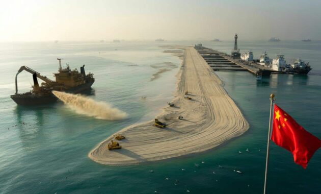
You smell diesel, wet sand and hot metal. Seabirds circle, confused, over what used to be part of their world. A Chinese dredger groans nearby, sucking up more sand from the seabed and spitting it onto a growing shore that wasn’t on any map fifteen years ago.
From the deck, the message is brutally clear: where there was nothing, there is now a brand-new island, flying a red flag and bristling with antennas.
China’s man-made islands: when maps start lying
If you glance at an old atlas of the South China Sea, you’ll see scattered reefs and awkwardly named rocks, barely dots on the page. Look at a recent satellite image on your phone and the picture is totally different. Wide grey runways. Harbors carved with military precision. A necklace of artificial islands, planted in turquoise water along some of the world’s busiest shipping lanes.
These are China’s sand-built outposts. They didn’t appear slowly, like natural coral. They arrived in a rush of dredgers, concrete and political ambition. For more than a decade, millions of tonnes of sand have been poured into the ocean, turning hidden reefs into *permanent statements* of power.
Take Fiery Cross Reef, once just a tiny feature barely breaking the surface at high tide. In 2014, it was mostly known to fishermen and the occasional naval patrol. A few years later, satellite photos showed a thick airstrip, hangars, radar domes and a deep-water port. The reef had become an island, with enough infrastructure to host fighter jets and surveillance planes.
Zoom in on Mischief Reef, Subi Reef, or Cuarteron Reef and the pattern repeats. Each place transformed from obscure coral into what analysts dryly call “unsinkable aircraft carriers”. Local fishermen from the Philippines and Vietnam now talk about patrolling coastguard ships and blinding floodlights where they once cast nets in the dark. The geography changed so fast that many sea maps went out of date almost overnight.
Behind the visual shock, there is a hard logic to all this sand. The South China Sea is one of the planet’s busiest maritime crossroads, carrying trade worth trillions of dollars every year. Whoever controls the reefs and shoals scattered across it gains leverage over sea routes, fish stocks and possible energy reserves under the seabed. By turning contested reefs into solid, fortified islands, Beijing isn’t just building territory. It’s strengthening its claim to surrounding waters that many neighboring countries – and global powers – see as international.
There’s also a psychological edge. A squiggle on a map is easy to argue about. A runway, a radar station and a pier filled with coastguard vessels are much harder to ignore. That’s the quiet power of dumping sand into the sea until everyone else has to deal with what’s suddenly “real”.
How to build a new island: dredgers, sand and a lot of patience
Creating land from open sea sounds like science fiction, but the basic method is brutally straightforward. First, identify a reef or shallow shoal – something that’s already a bump in the seabed. Then send in massive trailing suction hopper dredgers, ships that act like giant vacuum cleaners. They suck sand and sediment from the ocean floor nearby, storing it in their holds.
➡️ ISS astronauts witness mysterious lights over the Pacific just before a massive radiation burst
Once loaded, these ships sail back over the chosen reef and pump the sand out through long pipes. The sludge splashes across the coral, layer after layer, until a rough shape emerges above the waves. Bulldozers and excavators move in to compact, level and stabilize the new ground, ready for foundations, roads and runways.
On paper, it sounds almost elegant. On the water, it’s anything but. The process churns up clouds of sediment, smothering coral and driving away marine life that can’t escape fast enough. Fishermen from neighboring countries have reported dead fish floating near dredging sites and once-clear waters turning murky for weeks. We’ve all been there, that moment when you realize a “development project” isn’t just lines on a government briefing, but something that permanently changes a place you knew.
Beyond the immediate reef, the hunger for sand has its own chain reaction. Coastal areas and riverbeds become extraction zones, feeding the appetite of dredgers. Scientists warn about eroding shorelines and collapsing habitats. For the surrounding states, there’s another fear: watch enough sand be moved, and you might also be watching a new reality being cemented around you.
From Beijing’s perspective, this is long-term strategy, not a wild construction spree. The narrative from Chinese officials emphasizes **civilian facilities**, lighthouses, search-and-rescue, and scientific stations, framed as contributions to regional safety. At the same time, the installations clearly include hangars sized for combat aircraft, hardened shelters and anti-aircraft systems. Let’s be honest: nobody really believes this is just about weather monitoring.
International reactions swing between outrage and wary pragmatism. Legal cases have gone to international tribunals, naval patrols sail past in “freedom of navigation” operations, and neighboring governments lodge diplomatic notes that change nothing on the ground – or rather, on the newly created ground. Analysts quietly point out that once the sand is there, and the concrete is poured, rolling it back is almost impossible without a crisis nobody wants.
How to read these islands like a geopolitical weather report
For anyone watching from afar on a phone screen, these islands can feel abstract. A better approach is to treat each new strip of sand as a clue. Start by asking three simple questions: Where is it? What is being built on it? Who responds visibly when it grows? If the island sits near a shipping lane or a contested boundary, grows a runway and a dock, and suddenly attracts foreign surveillance flights, you’re not just looking at sand. You’re looking at a new pressure point.
This is one of those topics where a quick scroll through satellite images tells more than a stack of diplomatic statements. The shapes, shadows and ship tracks around these islands are a kind of real-time weather map of regional tension.
A common mistake is to see each island in isolation, like separate news items. That’s how we get lost in names and acronyms. The emotional trap is real: you read about one reef, then another, and it all blends into background noise. A more grounded way is to see them as a chain. Connect Fiery Cross to Subi to Mischief, and suddenly you’re looking at a web of runways and sensor coverage stretched across the sea.
There’s also the human side, often buried under military jargon. Filipino fishers who now keep their distance. Vietnamese crews who talk about being chased off waters their fathers fished. Chinese workers who spend months at sea on dredgers, living inside this project of national ambition. The big picture is made of these small, quiet stories.
“Sand is not just sand anymore,” a Southeast Asian diplomat told a regional forum off the record. “Every grain poured on those reefs weighs something in our politics.”
- Watch the runways: Short airstrips hint at patrol planes; long ones suggest fighter jets and heavy transports.
- Count the ships: A cluster of coastguard or militia vessels signals active enforcement, not just symbolic claims.
- Track the pace: Rapid land expansion usually matches moments of diplomatic tension or global distraction.
- Note the dual-use design: Harbors and warehouses can host both civilian supplies and military hardware.
- Follow who visits: High-level tours, flag-raising ceremonies and drills show how “normalized” an island has become.
When the sea turns into real estate – and everyone pays attention
China’s sand-made islands in the South China Sea are more than a technical feat. They’re a test of how far a country can go in reshaping the physical world to suit its strategic map. Millions of tonnes of sand have shifted not just the shape of reefs, but the balance of power over routes that carry our phones, clothes and fuel. The draglines of those dredgers run straight into global supply chains.
These islands also raise uncomfortable questions. Who gets to decide where land begins and ends when technology can redraw coastlines in a few seasons? How do you weigh the promise of development against reefs crushed under fresh concrete? And what happens when other states, watching closely, decide to copy the playbook?
For now, the new islands stand like punctuation marks in the middle of the sea, each one a bold, sandy comma in a sentence that isn’t finished yet. The maps will keep changing. The real story is how we choose to read them.
| Key point | Detail | Value for the reader |
|---|---|---|
| China builds islands with sand dredged from the seabed | Millions of tonnes of sand are pumped onto reefs, then compacted and built over | Helps decode how “impossible” projects at sea are made real |
| These islands sit on major trade routes | Runways, ports and radars extend control across the South China Sea | Shows why faraway construction affects global shipping and prices |
| Each new island is a political signal | Facilities, ship traffic and foreign reactions reveal shifting power | Gives readers simple cues to read satellite images and news with more insight |
FAQ:
- Question 1How does China actually turn reefs into solid islands?
- Question 2Why focus so much on the South China Sea for these projects?
- Question 3Are these islands legal under international law?
- Question 4What are the environmental consequences of all this sand dumping?
- Question 5Could other countries start building similar artificial islands?