For a decade, the Xueying 601 has shuttled people, fuel and instruments across the frozen continent, turning scattered Chinese outposts into a connected scientific network – and giving Beijing a new kind of leverage at the bottom of the planet.
A snow eagle at the end of the Earth
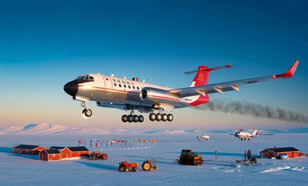
The aircraft at the centre of this story is called Xueying 601, usually translated as “Snow Eagle 601”. On paper, it is a polar-capable fixed‑wing aircraft used for logistics and science. In practice, it has become China’s airborne backbone in Antarctica.
Since entering Antarctic service around a decade ago, Xueying 601 has flown between Chinese stations and foreign bases, dropped scientists onto remote ice domes, and mapped vast stretches of the continent’s hidden bedrock. Its role sits somewhere between cargo hauler, rescue asset and flying laboratory.
Beijing now treats Xueying 601 not as a simple support plane, but as strategic infrastructure for both science and presence in Antarctica.
On 17 December 2025, during China’s 42nd Antarctic expedition, the aircraft launched its first scientific sorties of the season. These were not simple supply hops. They were early flights in what Chinese officials describe as an emerging “Antarctic air corridor”, with Zhongshan Station as the main hub and more than 20 national and international bases reachable within its range.
Building an airport on moving ice
When Snow Eagle 601 started its Antarctic career, China lacked one critical piece of infrastructure: its own continental runway.
The first missions depended heavily on foreign airstrips and logistics, especially those run by longer-established Antarctic players such as Australia, the United States and Russia. That reliance clashed with Beijing’s ambition to run regular, predictable polar operations on its own terms.
The Chinese answer was blunt: build an airfield where no conventional ground exists – on ice itself.
A step‑by‑step polar construction timeline
- 2022 – completion of China’s first dedicated polar ice runway near Zhongshan Station, using a sled‑type compacted ice design.
- March 2023 – the runway enters operational service, taking regular flights from Xueying 601 and other aircraft.
- May 2024 – the International Civil Aviation Organization (ICAO) assigns the airfield an official code, ZSSW. It is formally named Zhongshan Ice and Snow Airport.
Engineers compacted the surface, measured cracks and monitored seasonal shifts to keep the strip stable. The result is an ice runway that now operates more than 300 days per year, an impressive figure in such a harsh environment.
➡️ The unexpected trick of cleaning glass stovetops using baking soda paste
➡️ The small habit that keeps daily life flowing smoothly
Snow Eagle 601 has conducted close to 100 take‑offs and landings there without a reported incident, a track record that Chinese media present as evidence of both technical mastery and careful risk management rather than polar bravado.
Zhongshan Ice and Snow Airport gives China something new in Antarctica: home‑grown air access that does not depend on anyone else’s timetable.
The workhorse life of Xueying 601
In ten years of operations, Xueying 601 has accumulated more than 1,100 operational days, about 2,500 flight hours and roughly 800,000 kilometres flown – around 20 laps of Earth at the equator.
These numbers are modest by commercial aviation standards, but they mean something quite different in Antarctica. Each flight involves temperatures far below freezing, thin air that changes aircraft performance, and visual conditions that can switch from bright white to total flat‑light in minutes.
Pilots often land on surfaces where snow, ice and sky blur into one featureless sheet. That demands intense instrument flying skills, robust navigation systems and crews trained to handle a margin of error that shrinks dramatically with altitude and cold.
Antarctic surfaces also punish mistakes. A misjudged approach can lead to long overruns, crevasse risks or damage to landing gear on rough ice. Frozen fuel, brittle materials and limited ground support add yet more layers of complexity.
More than a cargo hauler
On its simplest days, Snow Eagle 601 behaves like a conventional cargo aircraft. It ferries drums of fuel to forward stations, delivers food and spare parts, and rotates teams of researchers between coastal bases and inland camps.
Yet its real value lies in what sits in the racks behind the cockpit: specialised scientific instruments. The aircraft has evolved into what Chinese officials happily describe as a “flying scientific instrument”.
- Transport role – freight, fuel, survival gear, field vehicles and personnel.
- Survey role – radar and gravimetry instruments probing ice thickness and sub‑glacial geology.
- Testbed role – proving how aircraft behave at high‑altitude polar sites such as Dome A.
- Emergency role – scouting landing sites and potential corridors for medical or rescue missions.
In 2016, Xueying 601 flew low‑level survey lines over Kunlun Station, perched more than 4,000 metres above sea level on the Antarctic plateau. The goal was to measure performance and safety margins in extremely thin, cold air before attempting landings.
By the following year, the aircraft managed to take off and land at Kunlun itself, a technical milestone that opened the way to more regular operations over the near‑mythical interior plateau, one of the least accessible regions on Earth.
In 2023 it completed a first landing in the Grove Mountains region of East Antarctica, seen by Chinese planners as a potential new axis for emergency or science flights.
Seeing through a continent of ice
Antarctica’s surface looks deceptively simple: endless white. What really matters for climate and geology lies underneath – the shape of the bedrock, the heat it emits, the valleys guiding ice flow toward the ocean.
This is where Xueying 601 shifts from logistics aircraft to scientific asset.
Equipped with radar and other sensors, Snow Eagle 601 has flown more than 200,000 kilometres of observation lines over East Antarctica, turning gaps on the map into usable data.
Many of those flights focused on Princess Elizabeth Land and surrounding sectors of East Antarctica, regions that are key to global sea‑level projections yet historically under‑sampled compared with West Antarctica.
Using airborne radar and gravimetric instruments, researchers can:
- Map the relief under the ice sheet with high precision.
- Estimate geothermal heat flow coming from Earth’s crust.
- Identify deep troughs where warm water could intrude under the ice in future.
- Assess how fast ice might slide or thin along specific corridors.
These measurements feed directly into ice‑sheet models. Without this kind of detail, simulations of future sea‑level rise remain imprecise, forcing planners to work with wide uncertainty bands.
Cooperation tool – and a subtle power signal
Although Snow Eagle 601 is proudly Chinese, it does not fly in isolation. Beijing uses the aircraft within wider scientific partnerships, whilst also advancing its own polar strategy.
China participates in the RINGS airborne geophysics initiative under the Scientific Committee on Antarctic Research, working with countries including Norway and Australia to observe the margins of East Antarctica, particularly in Enderby Land and neighbouring coastal regions.
Since 2024, Chinese teams have also taken on responsibilities for managing airspace around Zhongshan Station. That includes drafting and testing operational procedures, which are then aligned with international standards to keep mixed‑nation traffic safe in a region with limited radar coverage.
The aircraft functions as both a research asset and a quiet signal that China intends to be a long‑term, rules‑shaping player in Antarctica.
Part of a small but critical club of polar aircraft
Only a handful of aircraft types can routinely handle Antarctic conditions. Snow Eagle 601 now sits firmly within that elite group.
| Aircraft | Main operators | Primary role | Ice landing | Notable feature |
|---|---|---|---|---|
| Xueying 601 | China | Logistics and science | Yes | High level of onboard research capability |
| Basler BT‑67 | US and partners | Heavy logistics | Yes | Rugged, long‑proven in polar work |
| Twin Otter | UK, EU states, Canada | Precision science and light transport | Yes | Exceptional performance from short, rough strips |
| C‑130 Hercules (ski‑equipped) | United States | Strategic logistics | Yes | Can deliver large loads to the South Pole |
| Il‑76 | Russia | Bulk transport | Limited | Very long range for intercontinental runs |
What sets Xueying 601 apart is its hybrid positioning: more flexible and cheaper to operate than heavy giants, but more autonomous and capable than small science aircraft. It can open new corridors, support deep‑field stations and gather high‑quality data all on the same deployment.
China’s Antarctic network, viewed from the air
Snow Eagle 601 plugs into a broader Chinese strategy that aims to cover the continent from coast to summit with long‑running datasets.
| Station | Opened | Location | Main science areas | Role |
|---|---|---|---|---|
| Great Wall Station | 1985 | King George Island, Antarctic Peninsula | Marine biology, coastal climate, geology | First Chinese base and cooperation hub |
| Zhongshan Station | 1989 | East Antarctic coast | Glaciology, meteorology, geophysics | Logistics and air hub, gateway for Xueying 601 |
| Kunlun Station | 2009 | Dome A, interior plateau (>4,000 m) | Astronomy, upper‑atmosphere physics, deep ice | Key site for ancient climate and space observations |
| Taishan Station | 2014 | East Antarctica, mid‑way inland | Glaciology, geodesy, staging support | Relay between Zhongshan and Kunlun |
Together, these stations allow China to measure interactions between ocean, ice and atmosphere at the coast, then track how those signals propagate across the ice sheet towards the high interior. Aircraft like Snow Eagle 601 ensure supplies, instruments and people can move along that chain without depending entirely on ships and summer sea‑ice conditions.
For climate scientists worldwide, Chinese data from these sites, especially when shared through international programmes, can sharpen global climate models that feed into assessments by bodies such as the IPCC.
Why an Antarctic aircraft matters for everyday life
At first glance, the details of one Chinese aircraft landing on obscure ice runways might sound remote from daily concerns in London, New York or Nairobi. The link runs through sea‑level rise and extreme weather.
Most of the world’s long‑term sea‑level threat comes from Antarctica’s huge ice reserves. How fast that ice sheet responds to warming oceans and atmosphere depends on details like the shape of the bedrock, the amount of geothermal heat beneath the ice, and the exact geometry of valleys and ridges.
Those details are precisely what aircraft such as Xueying 601 measure. Better maps of East Antarctica can translate into more reliable projections of flood risk for coastal cities, from Miami to Mumbai. Insurance pricing, coastal defences and long‑term planning increasingly rely on narrowing the uncertainty around those projections.
Key terms worth unpacking
Two concepts show up repeatedly in discussions of aircraft like Snow Eagle 601:
- Sub‑glacial topography – the hills, mountains and basins hidden under the ice. Their shape controls how ice slides and where meltwater can pool.
- Geothermal heat flux – the heat that rises naturally from Earth’s interior. In some spots it can weaken ice from below and form hidden melt channels.
Airborne surveys measure these indirectly. Radar bounces off the rock beneath the ice, while gravimetric sensors detect changes in gravity that signal different rock types or basin depths. Repeated flights along the same tracks show how ice thickness changes over time.
As climate negotiations shift from abstract targets towards adaptation plans and loss‑and‑damage funding, this kind of hard data becomes a currency of its own. Countries that can provide reliable Antarctic measurements help shape global baselines for risk – and, by extension, financial flows.
Risks and future scenarios
Relying heavily on a small fleet of aircraft for polar work brings vulnerabilities. Mechanical issues, accidents or political tensions could all disrupt Antarctic air corridors. Harsh weather already limits flying windows, making it tricky to guarantee emergency access year‑round.
There is also a geopolitical dimension. More capable polar aviation lets states extend their reach deeper into Antarctica, raising quiet questions about how far scientific activity shades into strategic positioning, even under the constraints of the Antarctic Treaty.
In a plausible future scenario, multiple nations could field more advanced polar aircraft with autonomous navigation, satellite‑based communication links and hybrid propulsion. That might boost safety and science, while also intensifying competition for logistics hubs, runways and airspace management roles.
For now, though, one fact stands: Snow Eagle 601 has given China a reliable set of wings over Antarctica. Not just any wings, but ones that carry both barrels of fuel and hard climate data – and, increasingly, a say in how the frozen continent is understood and used.